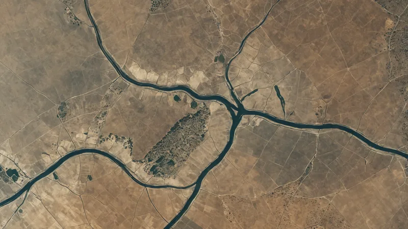
At 6:40 a.m., a transmission operations manager in Maryland is deciding whether to dispatch a two-person crew to a suspected encroachment near a river crossing. A contractor's work vehicle was reported close to the right-of-way, but the last scheduled overflight was several weeks ago. Before calling out the crew, she checks recent satellite imagery, compares it with the corridor's inspection history, and looks for a corresponding change in the site's sensor and camera feeds.
The image does not settle every question. It does show that a new access track appears to stop short of the protected corridor, with no visible excavation or equipment at the reported location. The manager marks the alert for continued monitoring instead of sending a crew immediately. If the next image shows movement toward the line, or if a field sensor reports a related change, the dispatch decision will be different.
Two inspection methods, different jobs
Field inspection and geospatial monitoring are often described as competing approaches. In practice, they answer different operational questions.
A field crew can inspect a gate, walk a right-of-way, photograph a structure, verify a lock, speak with a landowner, or determine whether a surface disturbance is actually connected to an asset. A person on site can see details that are difficult or impossible to infer remotely. Field work is also the usual path to ground truth when an anomaly is unfamiliar or carries safety, maintenance, or compliance consequences.
Geospatial monitoring addresses a different problem: what changed, where did it change, and how quickly can the operations team decide whether it matters? Satellite imagery provides repeatable views across a broad corridor. Synthetic aperture radar, or SAR, can add observations when optical imagery is affected by darkness or some types of cloud cover. Live video and sensor feeds can add context between image refreshes.
For a utility or environmental monitoring team, that distinction matters. A quarterly overflight or scheduled patrol may provide a detailed snapshot, but it leaves intervals in which an encroachment, grading project, vegetation removal, or flood-related change can develop. Monitoring does not eliminate those inspections. It gives the team a way to focus them.
Where geospatial monitoring has an operational advantage
The first advantage is coverage. A team responsible for hundreds of miles of transmission corridor, pipeline, access road, or watershed cannot watch every location continuously with personnel. A spatial monitoring system can maintain a common view of known assets and areas of interest, then direct attention to locations where conditions have changed.
The second is frequency. A field inspection schedule is shaped by travel time, access, weather, staffing, and safety procedures. Imagery and connected data can support more frequent review without sending a vehicle to every site. That is particularly useful between planned patrols, after severe weather, or when a report from a landowner, contractor, or control room needs a fast initial assessment.
The third is comparison. A useful monitoring workflow is not just a map with a new image on top. It compares current and prior conditions, records the location of a change, and routes an alert to the people responsible for deciding what happens next. Configurable rules can distinguish a known maintenance area from a new structure, excavation pattern, or activity inside a protected boundary.
That process can reduce low-value dispatches. It can also prevent a reported issue from sitting unreviewed until the next inspection cycle. The value is not that every alert is correct. The value is that each alert enters a consistent triage process with supporting context.
A practical comparison for infrastructure teams
| Operational need | Geospatial monitoring | Field inspection |
|---|---|---|
| Wide-area screening | Reviews broad corridors and multiple locations without travel to each site | Requires planned routes, access, and crew time |
| Change detection | Compares current and prior imagery or sensor conditions | Provides direct observation at a selected location |
| Immediate physical verification | Can indicate where to look, but may not resolve the cause | Can inspect equipment, surfaces, access points, and surrounding conditions |
| Repeatability | Creates a consistent record of observations over time | Results can vary with route, weather, lighting, and inspector availability |
| Novel or high-consequence anomaly | Supports prioritization and context | Usually required to establish ground truth and determine action |
The comparison points toward a tiered workflow rather than a single replacement technology. Monitoring can screen the full network, rank alerts, and provide evidence before dispatch. A field crew can then investigate the smaller set of locations that require direct observation.
For example, a Chesapeake-area pipeline operator might use optical imagery between quarterly overflights to check a suspected encroachment. If the location shows a new access route but no activity inside the right-of-way, the operator can continue watching it and attach the finding to the work queue. If repeated imagery shows grading moving toward the corridor, the alert can be escalated. The crew arrives with a location, time series, and specific question instead of a vague report that something may be happening nearby.
What remote monitoring cannot tell you
Geospatial monitoring has real limits. Optical imagery can be affected by cloud cover, haze, shadows, and seasonal vegetation. SAR has different strengths, but its interpretation can be difficult in areas with complex terrain, dense built environments, or frequent surface changes. Spatial resolution also limits what can be identified. An image may show that material has appeared at a site without showing whether it is pipe, construction equipment, debris, or a temporary stack of supplies.
Remote sensing primarily observes the surface. It does not replace a technician testing a valve, opening a cabinet, checking a grounding connection, or evaluating conditions below grade. A camera may show activity without explaining its purpose. A sensor may report an unusual value without identifying the mechanical cause.
False positives are part of the operating model. Construction, mowing, agricultural work, snow, flooding, and approved maintenance can all resemble unauthorized change. Rules therefore need location-specific context, prior work records, and a way for operators to label an alert as expected, unresolved, or requiring inspection. Novel anomaly types should be treated cautiously until someone has verified what the system is seeing.
This isn't an argument against field visits. It is a case for making them deliberate. The point is not to stop sending crews. It is to stop sending them blind, and to avoid treating every low-confidence report as an emergency dispatch.
Building a combined inspection workflow
A practical program starts by defining the decisions that monitoring should support. Those decisions might include whether to dispatch a crew, whether to request a landowner contact, whether to escalate a safety concern, or whether to keep watching a low-confidence change. The team can then set rules for location, asset type, change category, confidence, and urgency.
The data sources should be connected to that decision process. Satellite imagery can provide the corridor-wide view. SCADA sensors can add operating context through protocols such as Modbus or DNP3. IP cameras can contribute live or recorded views through RTSP or ONVIF. An ArcGIS connection can keep asset records and review activity aligned with the organization's existing spatial workflows. Email, webhook, or API routing can send alerts to the system or team that owns the response.
Larx is built around this combined view. Its platform fuses SAR and optical imagery, sensor data, and camera feeds, then supports automated change and encroachment detection with configurable rules. For an operations team, the relevant output is not simply another map. It is a reviewable alert tied to a location, prior conditions, available context, and the next operational step.
That triage workflow is what Larx is built to support: confirming or denying an anomaly before a crew leaves the depot. When field verification is needed, the crew can be sent with a clearer target and a record of what triggered the decision. When it is not needed yet, the team can document why the location remains under observation and keep the next review in the same spatial workflow.
The most useful question is therefore not whether geospatial intelligence or field inspection is better. It is which one is sufficient for the decision in front of the team. If the question is whether something changed across a large corridor, start with monitoring. If the question is what a component, surface, or unfamiliar anomaly actually is, send someone to verify it. A manager who can make that distinction before dispatch has already improved the inspection process.